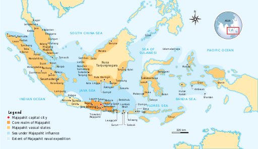
ຮູບ:Majapahit Empire.svg
Appearance

Size of this PNG preview of this SVG file: 512 × 297 ພິກເຊວ. ຄວາມລະອຽດອື່ນ ໆ: 320 × 186 ພິກເຊວ | 640 × 371 ພິກເຊວ | 1,024 × 594 ພິກເຊວ | 1,280 × 743 ພິກເຊວ | 2,560 × 1,485 ພິກເຊວ
ໄຟລ໌ຕົ້ນສະບັບ (SVG file, nominally 512 × 297 pixels, file size: 546 KB)
ປະຫວັດໄຟລ໌
ຄລິກທີ່ ວັນທີ/ເວລາ ເພື່ອເບິ່ງໄຟລ໌ດັ່ງທີ່ມັນປາກົດໃນເວລານັ້ນ
| ວັນເວລາ | ຮູບຍໍ່ | ມິຕິ | ຜູ້ໃຊ້ | ຄວາມເຫັນ | |
|---|---|---|---|---|---|
| ປະຈຸບັນ | 09:27, 6 ພະຈິກ 2024 |  | 512 × 297(546 KB) | Waniosa Amedestir | File uploaded using svgtranslate tool (https://svgtranslate.toolforge.org/). Added translation for th. |
| 13:07, 28 ຕຸລາ 2016 |  | 512 × 297(524 KB) | Gunkarta | Correction on Luwu location | |
| 10:13, 5 ພະຈິກ 2009 |  | 781 × 457(525 KB) | Gunkarta | Corrected the location of Malano in northeast coast of Borneo and Wanin/Onin in Papua (today Fak-fak). | |
| 15:43, 10 ສິງຫາ 2009 |  | 781 × 457(525 KB) | Gunkarta | Crop the map again | |
| 15:37, 10 ສິງຫາ 2009 |  | 781 × 463(529 KB) | Gunkarta | Crop the map | |
| 15:27, 10 ສິງຫາ 2009 |  | 986 × 610(582 KB) | Gunkarta | {{Information |Description={{en|1=The Nusantara Archipelago during the height of Majapahit Empire in XIV century. 1. The red dot is Trowulan; Majapahit capital city 2. The dark orange area is core realm of Majapahit on eastern part of Java 3. The light o |
ການໃຊ້ໄຟລ໌
ໜ້າຕໍ່ໄປນີ້ເຊື່ອມໂຍງຫາໄຟລ໌ນີ້:
ການໃຊ້ໄຟລ໌ທົ່ວໂລກ
ວິກິອື່ນ ໆ ຕໍ່ໄປນີ້ໃຊ້ໄຟລ໌ນີ້:
- ການໃຊ້ງານເທິງ ar.wikipedia.org
- ການໃຊ້ງານເທິງ arz.wikipedia.org
- ການໃຊ້ງານເທິງ ast.wikipedia.org
- ການໃຊ້ງານເທິງ ba.wikipedia.org
- ການໃຊ້ງານເທິງ bcl.wikipedia.org
- ການໃຊ້ງານເທິງ bg.wikipedia.org
- ການໃຊ້ງານເທິງ bn.wikipedia.org
- ການໃຊ້ງານເທິງ ca.wikipedia.org
- ການໃຊ້ງານເທິງ cs.wikipedia.org
- ການໃຊ້ງານເທິງ de.wikipedia.org
- ການໃຊ້ງານເທິງ en.wikipedia.org
- ການໃຊ້ງານເທິງ eo.wikipedia.org
- ການໃຊ້ງານເທິງ eu.wikipedia.org
- ການໃຊ້ງານເທິງ fa.wikipedia.org
- ການໃຊ້ງານເທິງ fi.wikipedia.org
- ການໃຊ້ງານເທິງ fr.wikipedia.org
- ການໃຊ້ງານເທິງ gl.wikipedia.org
- ການໃຊ້ງານເທິງ he.wikipedia.org
- ການໃຊ້ງານເທິງ hi.wikipedia.org
- ການໃຊ້ງານເທິງ id.wikipedia.org
- ການໃຊ້ງານເທິງ id.wikisource.org
- ການໃຊ້ງານເທິງ id.wiktionary.org
- ການໃຊ້ງານເທິງ it.wikipedia.org
- ການໃຊ້ງານເທິງ ja.wikipedia.org
- ການໃຊ້ງານເທິງ km.wikipedia.org
- ການໃຊ້ງານເທິງ ko.wikipedia.org
- ການໃຊ້ງານເທິງ lt.wikipedia.org
- ການໃຊ້ງານເທິງ min.wikipedia.org
- ການໃຊ້ງານເທິງ ml.wikipedia.org
- ການໃຊ້ງານເທິງ mr.wikipedia.org
- ການໃຊ້ງານເທິງ ms.wikipedia.org
- ການໃຊ້ງານເທິງ ne.wikipedia.org
- ການໃຊ້ງານເທິງ nl.wikipedia.org
View more global usage of this file.


