
ຮູບ:Outre-mer en sans Terre Adelie.png
ຂະໜາດຂອງຕົວຢ່າງນີ້: 800 × 342 ພິກເຊວ ຄວາມລະອຽດອື່ນ ໆ: 320 × 137 ພິກເຊວ | 640 × 273 ພິກເຊວ | 1,456 × 622 ພິກເຊວ
ໄຟລ໌ຕົ້ນສະບັບ (1,456 × 622 ປິກເຊລ, ຂະໜາດໄຟລ໌: 49 KB, MIME type: image/png)
ສະຫຼຸບ

|
This locator map image could be re-created using vector graphics as an SVG file. This has several advantages; see Commons:Media for cleanup for more information. If an SVG form of this image is available, please upload it and afterwards replace this template with
{{vector version available|new image name}}.
It is recommended to name the SVG file “Outre-mer en sans Terre Adelie.svg”—then the template Vector version available (or Vva) does not need the new image name parameter. |
| ລາຍລະອຽດ |
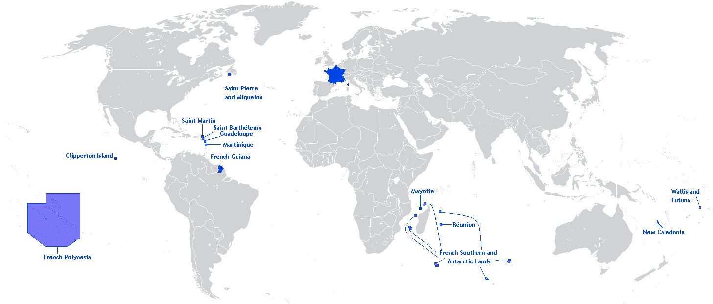
English: A map showing the Overseas departments and territories of France, excluding the territory of Adélie Land in Antarctica, where sovereignty is suspended |
| ວັນທີ | |
| Source | Own work |
| ຜູ້ຂຽນ | Originally Hoshie |
| Other versions | Adapted from File:Outre-mer en.png |
English: This image is a cropped version of Image:Outre-mer en.png initally created by user Hoshie. Antarctica was cropped.
Licensing
Hoshie, the copyright holder of this work, hereby publishes it under the following license:

|
Permission is granted to copy, distribute and/or modify this document under the terms of the GNU Free Documentation License, Version 1.2 or any later version published by the Free Software Foundation; with no Invariant Sections, no Front-Cover Texts, and no Back-Cover Texts. A copy of the license is included in the section entitled GNU Free Documentation License. |
| This file is licensed under the Creative Commons Attribution-Share Alike 3.0 Unported license. | ||
| Attribution: Hoshie | ||
| ||
| This licensing tag was added to this file as part of the GFDL licensing update. |
ປະຫວັດໄຟລ໌
ຄລິກທີ່ ວັນທີ/ເວລາ ເພື່ອເບິ່ງໄຟລ໌ດັ່ງທີ່ມັນປາກົດໃນເວລານັ້ນ
| ວັນເວລາ | ຮູບຍໍ່ | ມິຕິ | ຜູ້ໃຊ້ | ຄວາມເຫັນ | |
|---|---|---|---|---|---|
| ປະຈຸບັນ | 20:26, 27 ມີນາ 2018 | | 1,456 × 622(49 KB) | Maphobbyist | Upload |
| 12:01, 27 ພຶດສະພາ 2012 |  | 1,456 × 622(59 KB) | Hazhk | Changing color | |
| 20:47, 12 ກຸມພາ 2012 |  | 1,480 × 625(68 KB) | Spesh531 | same as File:Outre-mer en.png, without Antarctica | |
| 00:35, 21 ຕຸລາ 2010 |  | 1,431 × 655(54 KB) | Rosss | Better view of French Polynesia | |
| 21:23, 25 ພະຈິກ 2009 |  | 1,431 × 655(30 KB) | The Illusional Ministry | removed borer from french polynesia | |
| 21:22, 25 ພະຈິກ 2009 |  | 1,431 × 655(30 KB) | The Illusional Ministry | ||
| 03:31, 17 ທັນວາ 2007 |  | 1,431 × 655(35 KB) | Rosss | Wider margin | |
| 03:26, 17 ທັນວາ 2007 |  | 1,431 × 639(35 KB) | Rosss | This image is a cropped version of Image:Outre-mer en.png initally created by user Hoshie. Antartica was cropped. ==License== {{GFDL-user|Hoshie}} Category:World maps of Overseas France |
ການໃຊ້ໄຟລ໌
ບໍ່ມີໜ້າໃດ ລິ້ງຄ໌ ຫາ ໄຟລ໌ນີ້.
ການໃຊ້ໄຟລ໌ທົ່ວໂລກ
ວິກິອື່ນ ໆ ຕໍ່ໄປນີ້ໃຊ້ໄຟລ໌ນີ້:
- ການໃຊ້ງານເທິງ an.wikipedia.org
- ການໃຊ້ງານເທິງ awa.wikipedia.org
- ການໃຊ້ງານເທິງ bn.wikibooks.org
- ການໃຊ້ງານເທິງ ckb.wikipedia.org
- ການໃຊ້ງານເທິງ da.wikipedia.org
- ການໃຊ້ງານເທິງ dv.wikipedia.org
- ການໃຊ້ງານເທິງ en.wikipedia.org
- Regions of France
- Outline of France
- Wikipedia:Graphics Lab/Map workshop/Archive/Dec 2009
- Wikipedia:Graphics Lab/Map workshop/Archive/Jun 2012
- User:SkulkingMEDIA
- User:Andreapr94/sandbox/Infobox/Country
- User:Jonperez91/sandbox/Infoboxes/Country
- User:Ane San José/sandbox/Infobox/Country
- User:P.aurrecoechea/Sandbox/Infobox/Country
- User:Trizia9/sandbox/Infobox/Country
- User:Ibonarzua/sandbox/Infobox/Country
- User:Mikel M/sandbox/Infobox/Country
- ການໃຊ້ງານເທິງ en.wikibooks.org
- ການໃຊ້ງານເທິງ es.wikipedia.org
- ການໃຊ້ງານເທິງ et.wikipedia.org
- ການໃຊ້ງານເທິງ eu.wikipedia.org
- ການໃຊ້ງານເທິງ fa.wikipedia.org
- ການໃຊ້ງານເທິງ fr.wikipedia.org
- ການໃຊ້ງານເທິງ hi.wikipedia.org
- ການໃຊ້ງານເທິງ hy.wikipedia.org
- ການໃຊ້ງານເທິງ id.wikipedia.org
- ການໃຊ້ງານເທິງ id.wikibooks.org
- ການໃຊ້ງານເທິງ ilo.wikipedia.org
- ການໃຊ້ງານເທິງ ja.wikipedia.org
- ການໃຊ້ງານເທິງ lv.wikipedia.org
- ການໃຊ້ງານເທິງ mai.wikipedia.org
- ການໃຊ້ງານເທິງ min.wikipedia.org
- ການໃຊ້ງານເທິງ ml.wikipedia.org
- ການໃຊ້ງານເທິງ mzn.wikipedia.org
- ການໃຊ້ງານເທິງ ne.wikipedia.org
- ການໃຊ້ງານເທິງ nl.wikipedia.org
- ການໃຊ້ງານເທິງ no.wikipedia.org
- ການໃຊ້ງານເທິງ pa.wikipedia.org
- ການໃຊ້ງານເທິງ pcd.wikipedia.org
- ການໃຊ້ງານເທິງ pdc.wikipedia.org
- ການໃຊ້ງານເທິງ pt.wikipedia.org
- ການໃຊ້ງານເທິງ sah.wikipedia.org
- ການໃຊ້ງານເທິງ sh.wikipedia.org
View more global usage of this file.