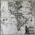
ຮູບ:MapaAméricaJonghe.JPG

ຂະໜາດຂອງຕົວຢ່າງນີ້: 597 × 600 ພິກເຊວ ຄວາມລະອຽດອື່ນ ໆ: 239 × 240 ພິກເຊວ | 478 × 480 ພິກເຊວ | 764 × 768 ພິກເຊວ | 1,019 × 1,024 ພິກເຊວ | 1,800 × 1,809 ພິກເຊວ
ໄຟລ໌ຕົ້ນສະບັບ (1,800 × 1,809 ປິກເຊລ, ຂະໜາດໄຟລ໌: 1.55 MB, MIME type: image/jpeg)
ປະຫວັດໄຟລ໌
ຄລິກທີ່ ວັນທີ/ເວລາ ເພື່ອເບິ່ງໄຟລ໌ດັ່ງທີ່ມັນປາກົດໃນເວລານັ້ນ
| ວັນເວລາ | ຮູບຍໍ່ | ມິຕິ | ຜູ້ໃຊ້ | ຄວາມເຫັນ | |
|---|---|---|---|---|---|
| ປະຈຸບັນ | 20:43, 10 ມັງກອນ 2010 |  | 1,800 × 1,809(1.55 MB) | Entheta | contrast. slight crop |
| 18:40, 6 ພຶດສະພາ 2005 |  | 1,830 × 1,840(1.8 MB) | Manuel González Olaechea | Map of America; ca. 1770. {{GFDL}} |
ການໃຊ້ໄຟລ໌
ໜ້າຕໍ່ໄປນີ້ເຊື່ອມໂຍງຫາໄຟລ໌ນີ້:
ການໃຊ້ໄຟລ໌ທົ່ວໂລກ
ວິກິອື່ນ ໆ ຕໍ່ໄປນີ້ໃຊ້ໄຟລ໌ນີ້:
- ການໃຊ້ງານເທິງ ar.wikipedia.org
- ການໃຊ້ງານເທິງ ca.wikipedia.org
- ການໃຊ້ງານເທິງ es.wikipedia.org
- Anexo:Ciudad de Pisco en los mapas históricos
- Usuario:Manuel González Olaechea y Franco/Galería de imágenes
- Historia territorial del Perú
- Discusión:Fronteras de Chile
- Usuario:Yakoo/Origen del término Pisco
- Usuario:Hispalois/mapas antiguos
- Usuario:Manuel González Olaechea y Franco/Galería de mapas de América
- ການໃຊ້ງານເທິງ es.wikinews.org
- ການໃຊ້ງານເທິງ fr.wikipedia.org
- ການໃຊ້ງານເທິງ kn.wikipedia.org
- ການໃຊ້ງານເທິງ pcd.wikipedia.org
- ການໃຊ້ງານເທິງ th.wikipedia.org
- ການໃຊ້ງານເທິງ vi.wikipedia.org
