
ຮູບ:Subtes-2015.svg

Size of this PNG preview of this SVG file: 694 × 599 ພິກເຊວ. ຄວາມລະອຽດອື່ນ ໆ: 278 × 240 ພິກເຊວ | 556 × 480 ພິກເຊວ | 889 × 768 ພິກເຊວ | 1,186 × 1,024 ພິກເຊວ | 2,371 × 2,048 ພິກເຊວ | 1,650 × 1,425 ພິກເຊວ
ໄຟລ໌ຕົ້ນສະບັບ (SVG file, nominally 1,650 × 1,425 pixels, file size: 143 KB)
| ລາຍລະອຽດ |
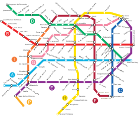
Español: Mapa de la red de subterráneos de la Ciudad de Buenos Aires hacia 2015, con todas las líneas proyectadas según ley 670 de la C.A.B.A.. |
||||||||
| Source | Galio, own work. | ||||||||
| ຜູ້ຂຽນ | Galio | ||||||||
| Permission (Reusing this file) |
I, the copyright holder of this work, hereby publish it under the following licenses:
This file is licensed under the Creative Commons Attribution 2.5 Generic license.
You may select the license of your choice. |

ປະຫວັດໄຟລ໌
ຄລິກທີ່ ວັນທີ/ເວລາ ເພື່ອເບິ່ງໄຟລ໌ດັ່ງທີ່ມັນປາກົດໃນເວລານັ້ນ
| ວັນເວລາ | ຮູບຍໍ່ | ມິຕິ | ຜູ້ໃຊ້ | ຄວາມເຫັນ | |
|---|---|---|---|---|---|
| ປະຈຸບັນ | 07:16, 11 ມັງກອນ 2016 | | 1,650 × 1,425(143 KB) | SegataSanshiro1 | Smaller station icons, made interchanges clearer. |
| 19:35, 1 ກັນຍາ 2015 |  | 1,650 × 1,425(169 KB) | SegataSanshiro1 | Colours changed to match official colours, added Premetro | |
| 05:37, 9 ມິຖຸນາ 2013 |  | 1,650 × 1,425(159 KB) | Galio | la denominación oficial de las estaciones es S. J. de Flores y San Pedrito, "Flores" a secas y Nazca son obsoletos | |
| 03:33, 11 ມິຖຸນາ 2010 |  | 1,650 × 1,425(132 KB) | Dexxter | Estaciones proyectadas de Línea A: Flores y Nazca. | |
| 23:52, 8 ກຸມພາ 2009 |  | 1,650 × 1,425(159 KB) | Galio | Modificación ubicación Carabobo | |
| 00:20, 26 ສິງຫາ 2008 |  | 1,650 × 1,425(159 KB) | Ojota | Category:Buenos Aires Metro | |
| 02:57, 14 ກໍລະກົດ 2008 |  | 1,650 × 1,425(158 KB) | Galio | {{Information |Description= |Source= |Date= |Author= |Permission= |other_versions= }} | |
| 01:18, 14 ກໍລະກົດ 2008 |  | 1,650 × 1,425(159 KB) | Galio | {{Information |Description= |Source= |Date= |Author= |Permission= |other_versions= }} {{ImageUpload|basic}} | |
| 22:15, 13 ກໍລະກົດ 2008 |  | 1,650 × 1,425(159 KB) | Galio | {{Information |Description= |Source= |Date= |Author= |Permission= |other_versions= }} | |
| 06:35, 13 ກໍລະກົດ 2008 |  | 1,650 × 1,425(161 KB) | Galio | == Sumario == Mapa de la red de subterráneos de la Ciudad de Buenos Aires hacia 2015, con todas las líneas proyectadas según ley 670 de la C.A.B.A. == Licensing == {{self2|GFDL|cc-by-2.5}} Category:Public transport maps of Buenos Aires {{ImageUpl |
ການໃຊ້ໄຟລ໌
ບໍ່ມີໜ້າໃດ ລິ້ງຄ໌ ຫາ ໄຟລ໌ນີ້.
ການໃຊ້ໄຟລ໌ທົ່ວໂລກ
ວິກິອື່ນ ໆ ຕໍ່ໄປນີ້ໃຊ້ໄຟລ໌ນີ້:
- ການໃຊ້ງານເທິງ ca.wikipedia.org
- ການໃຊ້ງານເທິງ en.wikipedia.org
- ການໃຊ້ງານເທິງ es.wikipedia.org
- ການໃຊ້ງານເທິງ fr.wikipedia.org
- ການໃຊ້ງານເທິງ hy.wikipedia.org
- ການໃຊ້ງານເທິງ id.wikipedia.org
- ການໃຊ້ງານເທິງ it.wikipedia.org
- ການໃຊ້ງານເທິງ ja.wikipedia.org
- ການໃຊ້ງານເທິງ nl.wikipedia.org
- ການໃຊ້ງານເທິງ ru.wikipedia.org
- ການໃຊ້ງານເທິງ th.wikipedia.org
- ການໃຊ້ງານເທິງ uk.wikipedia.org