
ຮູບ:Koppen-Geiger Map ARG present.svg

Size of this PNG preview of this SVG file: 512 × 423 ພິກເຊວ. ຄວາມລະອຽດອື່ນ ໆ: 291 × 240 ພິກເຊວ | 581 × 480 ພິກເຊວ | 930 × 768 ພິກເຊວ | 1,240 × 1,024 ພິກເຊວ | 2,479 × 2,048 ພິກເຊວ
ໄຟລ໌ຕົ້ນສະບັບ (SVG file, nominally 512 × 423 pixels, file size: 1.21 MB)
ສະຫຼຸບ
| ລາຍລະອຽດ |
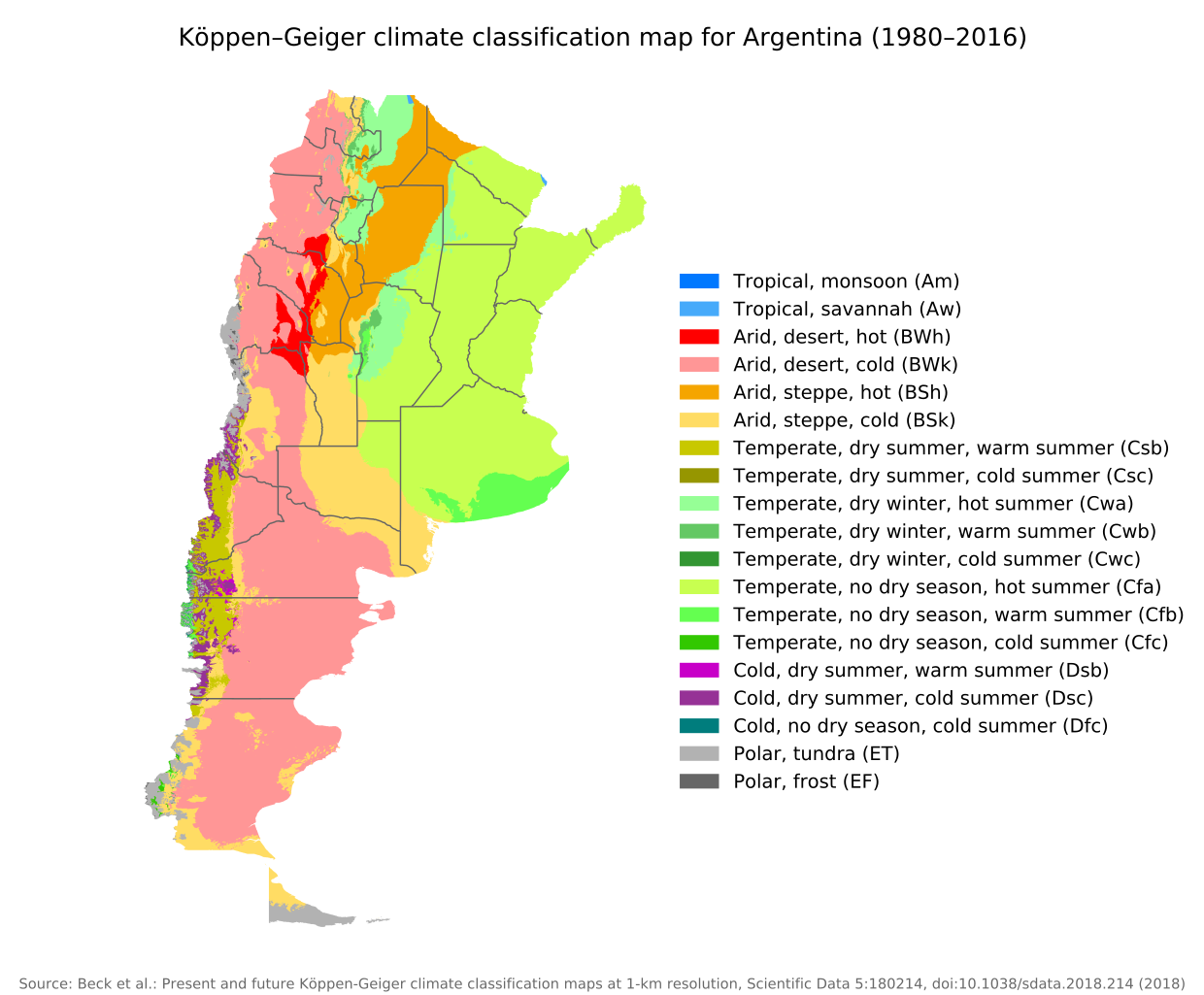
English: Köppen–Geiger climate classification map for Argentina |
| ວັນທີ | |
| Source | "Present and future Köppen-Geiger climate classification maps at 1-km resolution". Nature Scientific Data. DOI:10.1038/sdata.2018.214. |
| ຜູ້ຂຽນ | Beck, H.E., Zimmermann, N. E., McVicar, T. R., Vergopolan, N., Berg, A., & Wood, E. F. |
Licensing
This file is licensed under the Creative Commons Attribution 4.0 International license.
- You are free:
- to share – to copy, distribute and transmit the work
- to remix – to adapt the work
- Under the following conditions:
- ສະແດງທີ່ມາ – You must give appropriate credit, provide a link to the license, and indicate if changes were made. You may do so in any reasonable manner, but not in any way that suggests the licensor endorses you or your use.
| Camera location | | View this and other nearby images on: OpenStreetMap |
|---|
ປະຫວັດໄຟລ໌
ຄລິກທີ່ ວັນທີ/ເວລາ ເພື່ອເບິ່ງໄຟລ໌ດັ່ງທີ່ມັນປາກົດໃນເວລານັ້ນ
| ວັນເວລາ | ຮູບຍໍ່ | ມິຕິ | ຜູ້ໃຊ້ | ຄວາມເຫັນ | |
|---|---|---|---|---|---|
| ປະຈຸບັນ | 09:14, 8 ກັນຍາ 2020 | | 512 × 423(1.21 MB) | Allice Hunter | Provinces and adjustments |
| 15:44, 17 ກໍລະກົດ 2020 |  | 1,208 × 850(1.51 MB) | JPLema | Reverted to version as of 21:36, 15 June 2020 (UTC) | |
| 15:43, 17 ກໍລະກົດ 2020 |  | 840 × 812(1.45 MB) | JPLema | reducción de tamaño | |
| 21:36, 15 ມິຖຸນາ 2020 |  | 1,208 × 850(1.51 MB) | JPLema | Reverted to version as of 03:03, 26 November 2018 (UTC) | |
| 13:02, 15 ມິຖຸນາ 2020 |  | 696 × 1,006(1.34 MB) | JPLema | reduje el ancho y aumenté la altura | |
| 03:03, 26 ພະຈິກ 2018 |  | 1,208 × 850(1.51 MB) | NVergopolan | {{Information |Description={{en| Köppen–Geiger climate classification map for Argentina}}|date=2018-11-06|source={{cite journal | journal=Nature Scientific Data |doi=10.1038/sdata.2018.214}}|author=Beck, H.E., Zimmermann, N. E., McVicar, T. R., Vergopolan, N., Berg, A., & Wood, E. F.|permission=|other_versions=|other_fields=}}{{Cc-by-4.0}}{{Location|-38.42003918|-63.58480835}}Category:Köppen-Geiger Climate Classification MapsCategory:present climate (1980–2016)Category:Argentina[[... |
ການໃຊ້ໄຟລ໌
ບໍ່ມີໜ້າໃດ ລິ້ງຄ໌ ຫາ ໄຟລ໌ນີ້.
ການໃຊ້ໄຟລ໌ທົ່ວໂລກ
ວິກິອື່ນ ໆ ຕໍ່ໄປນີ້ໃຊ້ໄຟລ໌ນີ້:
- ການໃຊ້ງານເທິງ bg.wikipedia.org
- ການໃຊ້ງານເທິງ ckb.wikipedia.org
- ການໃຊ້ງານເທິງ en.wikipedia.org
- ການໃຊ້ງານເທິງ id.wikipedia.org
- ການໃຊ້ງານເທິງ ja.wikipedia.org
- ການໃຊ້ງານເທິງ km.wikipedia.org
- ການໃຊ້ງານເທິງ pt.wikipedia.org
- ການໃຊ້ງານເທິງ ru.wikipedia.org
- ການໃຊ້ງານເທິງ sr.wikipedia.org
- ການໃຊ້ງານເທິງ tr.wikipedia.org
- ການໃຊ້ງານເທິງ uk.wikipedia.org