
ຮູບ:Map of Vietnam 1829.jpg
ຂະໜາດຂອງຕົວຢ່າງນີ້: 399 × 599 ພິກເຊວ ຄວາມລະອຽດອື່ນ ໆ: 160 × 240 ພິກເຊວ | 320 × 480 ພິກເຊວ | 511 × 768 ພິກເຊວ | 682 × 1,024 ພິກເຊວ | 1,364 × 2,048 ພິກເຊວ | 3,464 × 5,200 ພິກເຊວ
ໄຟລ໌ຕົ້ນສະບັບ (3,464 × 5,200 ປິກເຊລ, ຂະໜາດໄຟລ໌: 8.83 MB, MIME type: image/jpeg)
ສະຫຼຸບ
| ລາຍລະອຽດ |
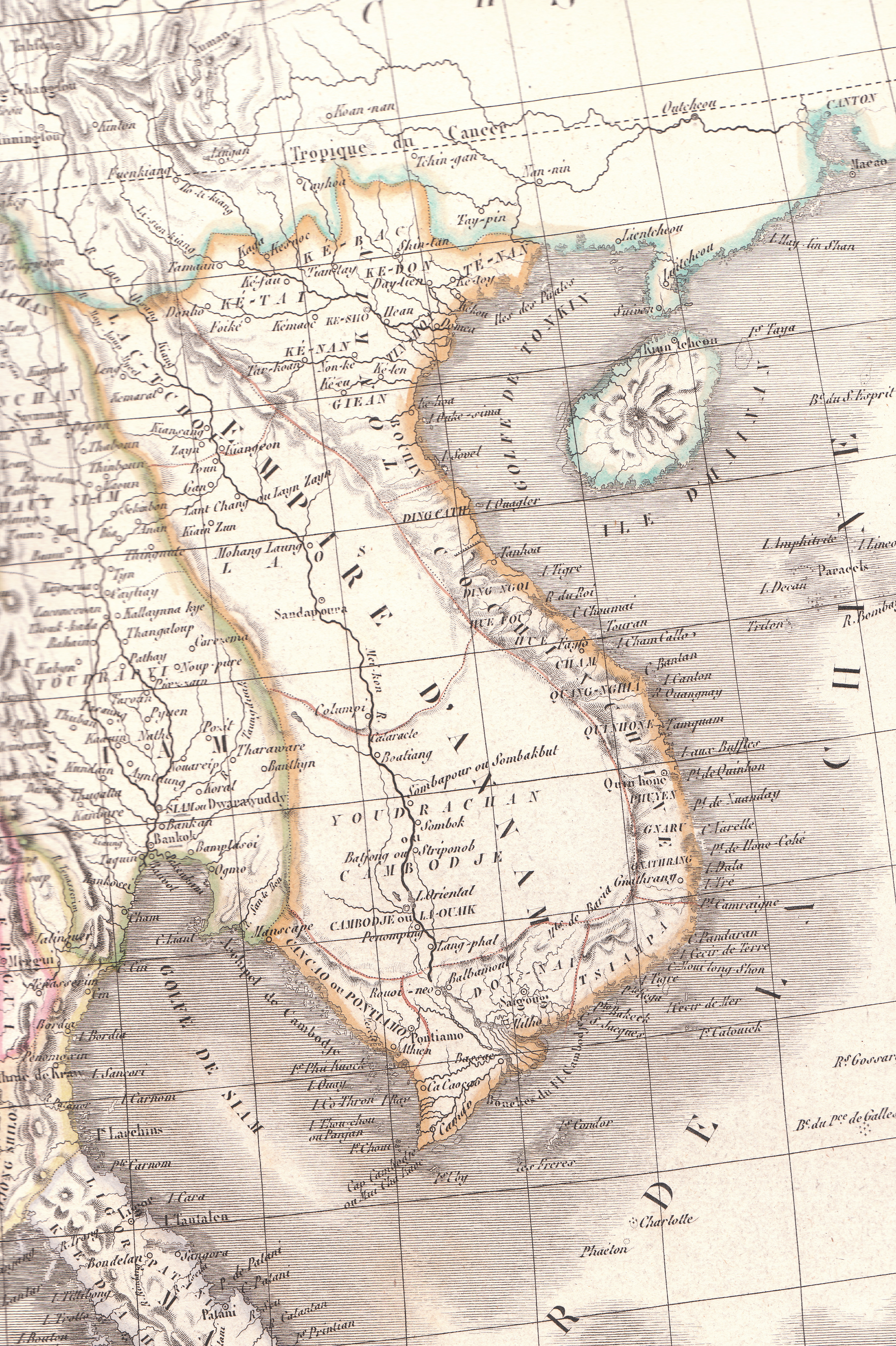
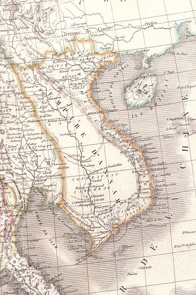
English: Plate 35E "Carte de l’Inde endeca et audela du Gange" from Lapie's Atlas Universel printed in 1829 |
| Source | Atlas Universel |
| ຜູ້ຂຽນ | Pierre M. Lapie |
Licensing
|
This work is in the public domain in its country of origin and other countries and areas where the copyright term is the author's life plus 70 years or fewer. This work is in the public domain in the United States because it was published (or registered with the U.S. Copyright Office) before January 1, 1929. | |
| This file has been identified as being free of known restrictions under copyright law, including all related and neighboring rights. | |
ປະຫວັດໄຟລ໌
ຄລິກທີ່ ວັນທີ/ເວລາ ເພື່ອເບິ່ງໄຟລ໌ດັ່ງທີ່ມັນປາກົດໃນເວລານັ້ນ
| ວັນເວລາ | ຮູບຍໍ່ | ມິຕິ | ຜູ້ໃຊ້ | ຄວາມເຫັນ | |
|---|---|---|---|---|---|
| ປະຈຸບັນ | 06:23, 26 ເມສາ 2010 | | 3,464 × 5,200(8.83 MB) | Duyet-pho | {{Information |Description={{en|1=Plate 35E "Carte de l’Inde endeca et audela du Gange" from Lapie's ''Atlas Universel'' printed in 1829}} |Source=Atlas Universel |Author=Pierre M. Lapie |Date= |Permission={{PD-1923}} |other_versions= }} [[Category:Map |
ການໃຊ້ໄຟລ໌
ບໍ່ມີໜ້າໃດ ລິ້ງຄ໌ ຫາ ໄຟລ໌ນີ້.
ການໃຊ້ໄຟລ໌ທົ່ວໂລກ
ວິກິອື່ນ ໆ ຕໍ່ໄປນີ້ໃຊ້ໄຟລ໌ນີ້:
- ການໃຊ້ງານເທິງ ca.wikipedia.org
- ການໃຊ້ງານເທິງ en.wikipedia.org
- ການໃຊ້ງານເທິງ eu.wikipedia.org
- ການໃຊ້ງານເທິງ gl.wikipedia.org
- ການໃຊ້ງານເທິງ id.wikipedia.org
- ການໃຊ້ງານເທິງ it.wikipedia.org
- ການໃຊ້ງານເທິງ pt.wikipedia.org
- ການໃຊ້ງານເທິງ ru.wikipedia.org
- ການໃຊ້ງານເທິງ th.wikipedia.org
- ການໃຊ້ງານເທິງ tr.wikipedia.org
- ການໃຊ້ງານເທິງ vi.wikipedia.org
- ການໃຊ້ງານເທິງ www.wikidata.org
- ການໃຊ້ງານເທິງ zh-min-nan.wikipedia.org
- ການໃຊ້ງານເທິງ zh-yue.wikipedia.org