
ຮູບ:Falklandsmap.gif
ບໍ່ມີຂະໜາດລະອຽດກວ່າ
Falklandsmap.gif (350 × 376 ປິກເຊລ, ຂະໜາດໄຟລ໌: 12 KB, MIME type: image/gif)
ສະຫຼຸບ
| ລາຍລະອຽດ |
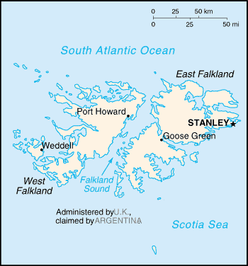
English: A map of the Falkland Islands (Islas Malvinas), showing island names and major towns. |
|||
| ວັນທີ | published 2004 | |||
| Source | CIA, The World Factbook, 2004. | |||
| ຜູ້ຂຽນ | CIA | |||
| Permission (Reusing this file) |
|

- first upload: March 27, 2004 - en:Wikipedia
| Camera location | | View this and other nearby images on: OpenStreetMap |
|---|
derivative works
Derivative works of this file: Weddell Island.PNG
ປະຫວັດໄຟລ໌
ຄລິກທີ່ ວັນທີ/ເວລາ ເພື່ອເບິ່ງໄຟລ໌ດັ່ງທີ່ມັນປາກົດໃນເວລານັ້ນ
| ວັນເວລາ | ຮູບຍໍ່ | ມິຕິ | ຜູ້ໃຊ້ | ຄວາມເຫັນ | |
|---|---|---|---|---|---|
| ປະຈຸບັນ | 16:11, 25 ກຸມພາ 2005 | | 350 × 376(12 KB) | Nordelch | {{PD}} |
ການໃຊ້ໄຟລ໌
ໜ້າຕໍ່ໄປນີ້ເຊື່ອມໂຍງຫາໄຟລ໌ນີ້:
ການໃຊ້ໄຟລ໌ທົ່ວໂລກ
ວິກິອື່ນ ໆ ຕໍ່ໄປນີ້ໃຊ້ໄຟລ໌ນີ້:
- ການໃຊ້ງານເທິງ azb.wikipedia.org
- ການໃຊ້ງານເທິງ be-tarask.wikipedia.org
- ການໃຊ້ງານເທິງ bs.wikipedia.org
- ການໃຊ້ງານເທິງ ca.wikipedia.org
- ການໃຊ້ງານເທິງ de.wikibooks.org
- ການໃຊ້ງານເທິງ en.wikibooks.org
- ການໃຊ້ງານເທິງ fi.wikipedia.org
- ການໃຊ້ງານເທິງ fr.wikipedia.org
- ການໃຊ້ງານເທິງ gl.wikipedia.org
- ການໃຊ້ງານເທິງ hr.wikipedia.org
- ການໃຊ້ງານເທິງ hr.wiktionary.org
- ການໃຊ້ງານເທິງ it.wikibooks.org
- ການໃຊ້ງານເທິງ ja.wikipedia.org
- ການໃຊ້ງານເທິງ mr.wikipedia.org
- ການໃຊ້ງານເທິງ no.wikipedia.org
- ການໃຊ້ງານເທິງ se.wikipedia.org
- ການໃຊ້ງານເທິງ th.wikipedia.org
- ການໃຊ້ງານເທິງ tr.wikipedia.org