
ຮູບ:EU-Croatia.svg

Size of this PNG preview of this SVG file: 713 × 600 ພິກເຊວ. ຄວາມລະອຽດອື່ນ ໆ: 285 × 240 ພິກເຊວ | 571 × 480 ພິກເຊວ | 913 × 768 ພິກເຊວ | 1,218 × 1,024 ພິກເຊວ | 2,435 × 2,048 ພິກເຊວ | 2,045 × 1,720 ພິກເຊວ
ໄຟລ໌ຕົ້ນສະບັບ (SVG file, nominally 2,045 × 1,720 pixels, file size: 7.33 MB)
ສະຫຼຸບ
| ລາຍລະອຽດ |
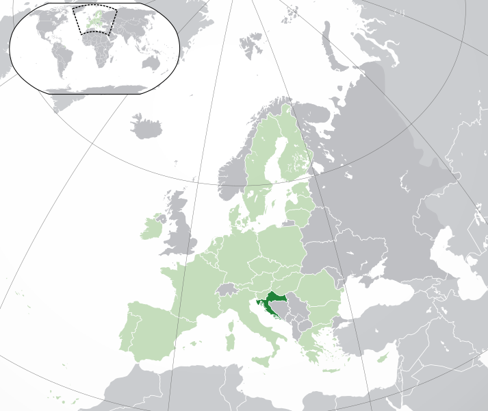
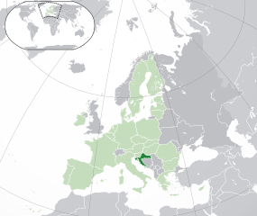
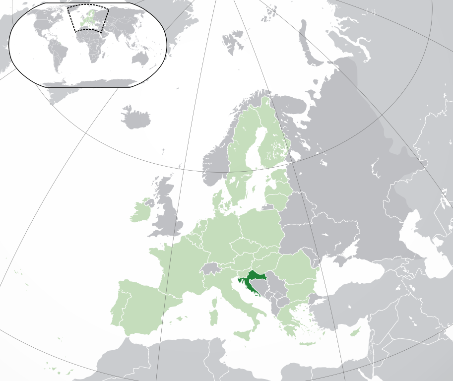
Français : (Vert) Croatie
(Vert clair) : Union Européenne (UE) (Gris) : Europe (Gris clair) : Région avoisinanteEnglish: (Green) : Croatia
(Light-green) : The European Union (EU) (Grey) : Europe (Light grey) : The surrounding region. |
| ວັນທີ | |
| Source | Own work |
| ຜູ້ຂຽນ | {{Atoine85}} |
| Other versions |
|
| SVG genesis |


Licensing
I, the copyright holder of this work, hereby publish it under the following license:
This file is licensed under the Creative Commons Attribution-Share Alike 3.0 Unported license.
- You are free:
- to share – to copy, distribute and transmit the work
- to remix – to adapt the work
- Under the following conditions:
- ສະແດງທີ່ມາ – You must give appropriate credit, provide a link to the license, and indicate if changes were made. You may do so in any reasonable manner, but not in any way that suggests the licensor endorses you or your use.
- ແບ່ງປັນຄືກັນ – If you remix, transform, or build upon the material, you must distribute your contributions under the same or compatible license as the original.
ປະຫວັດໄຟລ໌
ຄລິກທີ່ ວັນທີ/ເວລາ ເພື່ອເບິ່ງໄຟລ໌ດັ່ງທີ່ມັນປາກົດໃນເວລານັ້ນ
| ວັນເວລາ | ຮູບຍໍ່ | ມິຕິ | ຜູ້ໃຊ້ | ຄວາມເຫັນ | |
|---|---|---|---|---|---|
| ປະຈຸບັນ | 04:43, 1 ກຸມພາ 2020 | | 2,045 × 1,720(7.33 MB) | Rob984 | UK and Gibraltar have left the EU. New base which includes all of Portugal's islands within frame, as well as Arctic Russian islands part of Europe. Also fixed Flevoland in the Netherlands. |
| 16:54, 25 ຕຸລາ 2016 |  | 2,045 × 1,720(7.32 MB) | Giorgi Balakhadze | fix | |
| 16:37, 25 ຕຸລາ 2016 |  | 2,045 × 1,720(7.33 MB) | Giorgi Balakhadze | Rv of sockpuppet and per COM:OVERWRITE | |
| 16:26, 18 ມີນາ 2015 |  | 2,045 × 1,720(7.38 MB) | Mapclean | Reverted to Leftcry's version, please go to your talk page | |
| 14:03, 21 ກຸມພາ 2015 |  | 2,044 × 1,719(2.03 MB) | VS6507 | Spain. Greece. Slovakia. Cyprus. Romania VETO | |
| 19:35, 16 ພະຈິກ 2014 |  | 2,045 × 1,720(7.38 MB) | Leftcry | Reverted to version as of 22:33, 18 October 2014 Please go to your talk page | |
| 16:21, 16 ພະຈິກ 2014 |  | 2,044 × 1,719(2.03 MB) | A2D2 | The map must show the original de-jure status with no breakaway regions, as it was originally created. An alternative map showing the de-facto status with breakaway regions needs to created instead. | |
| 15:42, 16 ພະຈິກ 2014 |  | 2,045 × 1,720(7.38 MB) | A2D2 | Reverted to version as of 12:10, 16 August 2014 | |
| 22:33, 18 ຕຸລາ 2014 |  | 2,045 × 1,720(7.38 MB) | Leftcry | Minor fix | |
| 12:10, 16 ສິງຫາ 2014 |  | 2,045 × 1,720(7.38 MB) | DIREKTOR | Fixed overview. |
ການໃຊ້ໄຟລ໌
ໜ້າຕໍ່ໄປນີ້ເຊື່ອມໂຍງຫາໄຟລ໌ນີ້:
ການໃຊ້ໄຟລ໌ທົ່ວໂລກ
ວິກິອື່ນ ໆ ຕໍ່ໄປນີ້ໃຊ້ໄຟລ໌ນີ້:
- ການໃຊ້ງານເທິງ ace.wikipedia.org
- ການໃຊ້ງານເທິງ ady.wikipedia.org
- ການໃຊ້ງານເທິງ af.wikipedia.org
- ການໃຊ້ງານເທິງ ami.wikipedia.org
- ການໃຊ້ງານເທິງ ar.wikipedia.org
- كرواتيا
- مستخدم:ElWaliElAlaoui/ملعب 8
- معاملة المثليين في كرواتيا
- مستخدم:جار الله/قائمة صور مقالات العلاقات الثنائية
- العلاقات الأمريكية الكرواتية
- العلاقات الأنغولية الكرواتية
- العلاقات الكرواتية الكورية الجنوبية
- العلاقات الإريترية الكرواتية
- العلاقات السويسرية الكرواتية
- العلاقات الألمانية الكرواتية
- العلاقات الكرواتية الليختنشتانية
- العلاقات البوليفية الكرواتية
- العلاقات الكرواتية الموزمبيقية
- العلاقات الألبانية الكرواتية
- العلاقات البلجيكية الكرواتية
- العلاقات الإثيوبية الكرواتية
- العلاقات البيلاروسية الكرواتية
- العلاقات الطاجيكستانية الكرواتية
- العلاقات الروسية الكرواتية
- العلاقات الرومانية الكرواتية
- العلاقات الأرجنتينية الكرواتية
- العلاقات الغامبية الكرواتية
- العلاقات القبرصية الكرواتية
- العلاقات السيراليونية الكرواتية
- العلاقات الكرواتية النيبالية
- العلاقات الكرواتية الليبيرية
- العلاقات التشيكية الكرواتية
- العلاقات الكرواتية الميانمارية
- العلاقات الكرواتية الكندية
- العلاقات الزيمبابوية الكرواتية
- العلاقات الإسرائيلية الكرواتية
- العلاقات البالاوية الكرواتية
- العلاقات الكرواتية المالية
- العلاقات الكرواتية النيجيرية
- العلاقات اليمنية الكرواتية
- العلاقات الفانواتية الكرواتية
- العلاقات الغابونية الكرواتية
- العلاقات البنمية الكرواتية
- العلاقات الكرواتية الكوبية
- العلاقات الجورجية الكرواتية
- العلاقات الكرواتية الكورية الشمالية
- العلاقات الهندية الكرواتية
- العلاقات اليابانية الكرواتية
- العلاقات الإيطالية الكرواتية
- العلاقات الكرواتية الناوروية
- العلاقات الأسترالية الكرواتية
View more global usage of this file.