
ຮູບ:Colorado geographic map-en.svg

Size of this PNG preview of this SVG file: 703 × 599 ພິກເຊວ. ຄວາມລະອຽດອື່ນ ໆ: 282 × 240 ພິກເຊວ | 563 × 480 ພິກເຊວ | 901 × 768 ພິກເຊວ | 1,201 × 1,024 ພິກເຊວ | 2,403 × 2,048 ພິກເຊວ | 2,581 × 2,200 ພິກເຊວ
ໄຟລ໌ຕົ້ນສະບັບ (SVG file, nominally 2,581 × 2,200 pixels, file size: 7.2 MB)
ສະຫຼຸບ
| ລາຍລະອຽດ |
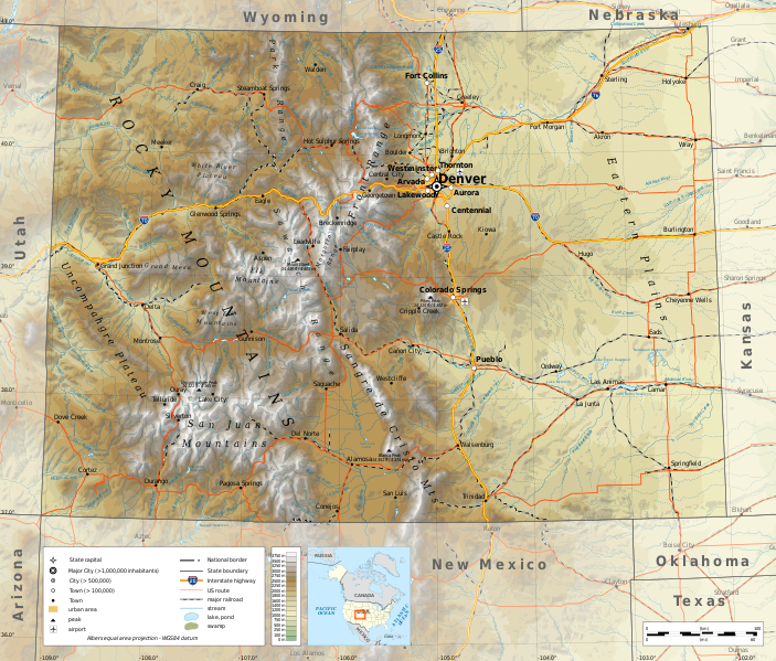
English: Geographic map of Colorado in English. Geographic limits of the map:
|
||
| ວັນທີ | |||
| Source |
Own work
|
||
| ຜູ້ຂຽນ | Ikonact | ||
| Permission (Reusing this file) |
Any use of this map is subject of the license(s) stated below with the condition that you credit (Wikimedia Commons user: Ikonact) as the author . A message with a reply address would also be greatly appreciated. | ||
| SVG genesis |
|
Licensing
I, the copyright holder of this work, hereby publish it under the following license:
This file is licensed under the Creative Commons Attribution-Share Alike 4.0 International license.
- You are free:
- to share – to copy, distribute and transmit the work
- to remix – to adapt the work
- Under the following conditions:
- ສະແດງທີ່ມາ – You must give appropriate credit, provide a link to the license, and indicate if changes were made. You may do so in any reasonable manner, but not in any way that suggests the licensor endorses you or your use.
- ແບ່ງປັນຄືກັນ – If you remix, transform, or build upon the material, you must distribute your contributions under the same or compatible license as the original.
ປະຫວັດໄຟລ໌
ຄລິກທີ່ ວັນທີ/ເວລາ ເພື່ອເບິ່ງໄຟລ໌ດັ່ງທີ່ມັນປາກົດໃນເວລານັ້ນ
| ວັນເວລາ | ຮູບຍໍ່ | ມິຕິ | ຜູ້ໃຊ້ | ຄວາມເຫັນ | |
|---|---|---|---|---|---|
| ປະຈຸບັນ | 19:49, 19 ມິຖຸນາ 2020 | | 2,581 × 2,200(7.2 MB) | Ikonact | eastern plains |
| 11:30, 23 ຕຸລາ 2019 |  | 2,581 × 2,200(6.7 MB) | Ikonact | svg valid, fall back font | |
| 21:21, 22 ຕຸລາ 2019 |  | 2,581 × 2,200(7.2 MB) | Ikonact | ++ | |
| 20:53, 22 ຕຸລາ 2019 |  | 2,581 × 2,200(7.2 MB) | Ikonact | mountain names | |
| 22:03, 21 ຕຸລາ 2019 |  | 2,581 × 2,200(7.19 MB) | Ikonact | + names | |
| 21:41, 21 ຕຸລາ 2019 |  | 2,581 × 2,200(7.19 MB) | Ikonact | == {{int:filedesc}} == {{Information |description={{en|1=Geographic map of Colorado in English. Geographic limits of the map:}} *N: 41.20° N *S: 38.80° N *W: 109.40° W *E: 101.60° W Albers equal area projection; WGS 84 datum |date=2019-10-21 |source={{own}} *Sources of data:<br/> **Topography: ETOPO1 (public domain);<br/> **Public domain data provided by the National Atlas of the United States of America;<br/> *Tool:<br/> **The map is created with Octave scripts developed by... |
ການໃຊ້ໄຟລ໌
ໜ້າຕໍ່ໄປນີ້ເຊື່ອມໂຍງຫາໄຟລ໌ນີ້:
ການໃຊ້ໄຟລ໌ທົ່ວໂລກ
ວິກິອື່ນ ໆ ຕໍ່ໄປນີ້ໃຊ້ໄຟລ໌ນີ້:
- ການໃຊ້ງານເທິງ ang.wikipedia.org
- ການໃຊ້ງານເທິງ be.wikipedia.org
- ການໃຊ້ງານເທິງ bg.wikipedia.org
- ການໃຊ້ງານເທິງ ca.wikipedia.org
- ການໃຊ້ງານເທິງ en.wikipedia.org
- ການໃຊ້ງານເທິງ es.wikipedia.org
- ການໃຊ້ງານເທິງ fr.wikipedia.org
- ການໃຊ້ງານເທິງ ga.wikipedia.org
- ການໃຊ້ງານເທິງ gl.wikipedia.org
- ການໃຊ້ງານເທິງ hu.wikipedia.org
- ການໃຊ້ງານເທິງ hy.wikipedia.org
- ການໃຊ້ງານເທິງ id.wikipedia.org
- ການໃຊ້ງານເທິງ it.wikipedia.org
- ການໃຊ້ງານເທິງ mhr.wikipedia.org
- ການໃຊ້ງານເທິງ os.wikipedia.org
- ການໃຊ້ງານເທິງ tg.wikipedia.org
- ການໃຊ້ງານເທິງ tt.wikipedia.org
- ການໃຊ້ງານເທິງ tum.wikipedia.org
- ການໃຊ້ງານເທິງ www.wikidata.org