
ຮູບ:Map of Iceland.svg

Size of this PNG preview of this SVG file: 739 × 600 ພິກເຊວ. ຄວາມລະອຽດອື່ນ ໆ: 296 × 240 ພິກເຊວ | 591 × 480 ພິກເຊວ | 946 × 768 ພິກເຊວ | 1,261 × 1,024 ພິກເຊວ | 2,523 × 2,048 ພິກເຊວ | 1,834 × 1,489 ພິກເຊວ
ໄຟລ໌ຕົ້ນສະບັບ (SVG file, nominally 1,834 × 1,489 pixels, file size: 717 KB)
ສະຫຼຸບ
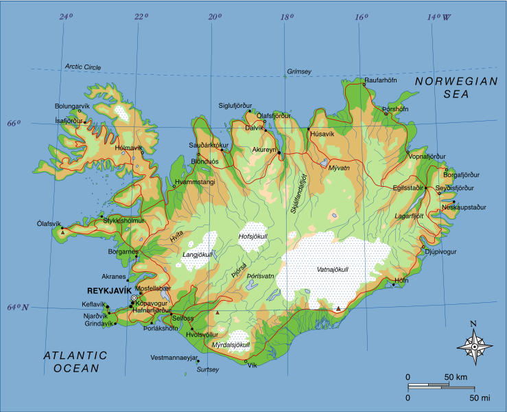
| ລາຍລະອຽດ | A map of Iceland, showing major towns, rivers, lakes and glaciers. Translated from a map on the Greek Wikipedia (located here). |
| ວັນທີ | |
| Source | Own work, based on File:Map of Iceland el.svg created by el:user:Αντιγόνη |
| ຜູ້ຂຽນ | Max Naylor |
Licensing
| This work has been released into the public domain by its author, I, Max Naylor. This applies worldwide. In some countries this may not be legally possible; if so: I, Max Naylor grants anyone the right to use this work for any purpose, without any conditions, unless such conditions are required by law. |
| Annotations | This image is annotated: View the annotations at Commons |
ປະຫວັດໄຟລ໌
ຄລິກທີ່ ວັນທີ/ເວລາ ເພື່ອເບິ່ງໄຟລ໌ດັ່ງທີ່ມັນປາກົດໃນເວລານັ້ນ
| ວັນເວລາ | ຮູບຍໍ່ | ມິຕິ | ຜູ້ໃຊ້ | ຄວາມເຫັນ | |
|---|---|---|---|---|---|
| ປະຈຸບັນ | 19:15, 23 ມິຖຸນາ 2007 | | 1,834 × 1,489(717 KB) | Max Naylor~commonswiki | == Summary == {{Information |Description=A map of Iceland, showing major towns, rivers, lakes and glaciers. Translated from a map on the Greek Wikipedia ([http://el.wikipedia.org/wiki/Εικόνα:Map_of_Iceland.svg located here]). |Source=self-made |Date |
| 19:11, 23 ມິຖຸນາ 2007 |  | 1,834 × 1,489(710 KB) | Max Naylor~commonswiki | == Summary == {{Information |Description=A map of Iceland, showing major towns, rivers, lakes and glaciers. Translated from a map on the Greek Wikipedia ([http://el.wikipedia.org/wiki/Εικόνα:Map_of_Iceland.svg located here]). |Source=self-made |Date | |
| 19:07, 23 ມິຖຸນາ 2007 |  | 1,834 × 1,489(694 KB) | Max Naylor~commonswiki | {{Information |Description=A map of Iceland, showing major towns, rivers, lakes and glaciers. Translated from a map on the Greek Wikipedia ([http://el.wikipedia.org/wiki/Εικόνα:Map_of_Iceland.svg located here]). |Source=self-made |Date=23 June 2007 |
ການໃຊ້ໄຟລ໌
ໜ້າຕໍ່ໄປນີ້ເຊື່ອມໂຍງຫາໄຟລ໌ນີ້:
ການໃຊ້ໄຟລ໌ທົ່ວໂລກ
ວິກິອື່ນ ໆ ຕໍ່ໄປນີ້ໃຊ້ໄຟລ໌ນີ້:
- ການໃຊ້ງານເທິງ af.wikipedia.org
- ການໃຊ້ງານເທິງ ar.wikipedia.org
- ການໃຊ້ງານເທິງ arz.wikipedia.org
- ການໃຊ້ງານເທິງ avk.wikipedia.org
- ການໃຊ້ງານເທິງ azb.wikipedia.org
- ການໃຊ້ງານເທິງ bg.wikipedia.org
- ການໃຊ້ງານເທິງ bn.wikipedia.org
- ການໃຊ້ງານເທິງ co.wikipedia.org
- ການໃຊ້ງານເທິງ cs.wikipedia.org
- ການໃຊ້ງານເທິງ da.wikipedia.org
- ການໃຊ້ງານເທິງ de.wikipedia.org
- ການໃຊ້ງານເທິງ de.wikibooks.org
- ການໃຊ້ງານເທິງ dz.wikipedia.org
- ການໃຊ້ງານເທິງ el.wikipedia.org
- ການໃຊ້ງານເທິງ en.wikipedia.org
- ການໃຊ້ງານເທິງ en.wikibooks.org
- ການໃຊ້ງານເທິງ en.wikiquote.org
- ການໃຊ້ງານເທິງ fa.wikipedia.org
- ການໃຊ້ງານເທິງ fi.wikipedia.org
- ການໃຊ້ງານເທິງ fo.wikipedia.org
- ການໃຊ້ງານເທິງ fr.wikipedia.org
- ການໃຊ້ງານເທິງ gag.wikipedia.org
- ການໃຊ້ງານເທິງ gv.wikipedia.org
- ການໃຊ້ງານເທິງ he.wikipedia.org
View more global usage of this file.