
ຮູບ:Map-of-southeast-asia 1400 CE.png
ຂະໜາດຂອງຕົວຢ່າງນີ້: 426 × 600 ພິກເຊວ ຄວາມລະອຽດອື່ນ ໆ: 170 × 240 ພິກເຊວ | 341 × 480 ພິກເຊວ | 791 × 1,114 ພິກເຊວ
ໄຟລ໌ຕົ້ນສະບັບ (791 × 1,114 ປິກເຊລ, ຂະໜາດໄຟລ໌: 190 KB, MIME type: image/png)

|
This historical map image could be re-created using vector graphics as an SVG file. This has several advantages; see Commons:Media for cleanup for more information. If an SVG form of this image is available, please upload it and afterwards replace this template with
{{vector version available|new image name}}.
It is recommended to name the SVG file “Map-of-southeast-asia 1400 CE.svg”—then the template Vector version available (or Vva) does not need the new image name parameter. |
ສະຫຼຸບ
| ລາຍລະອຽດ |
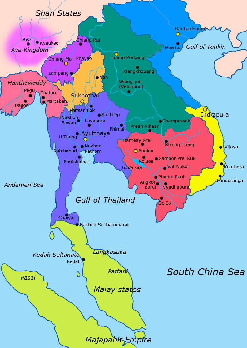
English: Map of Southeast Asia circa 1400 CE, showing Khmer Empire in red, Ayutthaya Kingdom in violet, Lan Xang kingdom in teal, Sukhothai kingdom in orange, Champa in yellow, Kingdom of Lanna in purple, Dai Viet in blue and surrounding states. |
| ວັນທີ | |
| Source |
http://ecaimaps.berkeley.edu/animations/2003_03_khmer_animation.swf http://www.britannica.com/EBchecked/media/3395/Khmer-empire-1200 Atlas of world history, Patrick Karl O'brien. Societies, Networks, and Transitions: A Global History, Volume B. Craig A.Lockard http://upload.wikimedia.org/wikipedia/commons/thumb/4/45/Srivijaya_Empire.svg/2000px-Srivijaya_Empire.svg.png File:DvaravatiMapThailand.png http://upload.wikimedia.org/wikipedia/commons/e/eb/Thailand_2002_CIA_map.jpg |
| ຜູ້ຂຽນ | Javierfv1212 |
Licensing
I, the copyright holder of this work, hereby publish it under the following license:
| This file is made available under the Creative Commons CC0 1.0 Universal Public Domain Dedication. | |
| The person who associated a work with this deed has dedicated the work to the public domain by waiving all of their rights to the work worldwide under copyright law, including all related and neighboring rights, to the extent allowed by law. You can copy, modify, distribute and perform the work, even for commercial purposes, all without asking permission.
|
ປະຫວັດໄຟລ໌
ຄລິກທີ່ ວັນທີ/ເວລາ ເພື່ອເບິ່ງໄຟລ໌ດັ່ງທີ່ມັນປາກົດໃນເວລານັ້ນ
| ວັນເວລາ | ຮູບຍໍ່ | ມິຕິ | ຜູ້ໃຊ້ | ຄວາມເຫັນ | |
|---|---|---|---|---|---|
| ປະຈຸບັນ | 22:54, 25 ມັງກອນ 2022 | | 791 × 1,114(190 KB) | Yourlocallordandsavior | Reverted to version as of 17:40, 7 March 2021 (UTC) Inaccurate. |
| 08:44, 22 ເມສາ 2021 |  | 1,080 × 1,521(643 KB) | Monaonh | Map-of-southeast-asia_1400_CE.png | |
| 17:40, 7 ມີນາ 2021 |  | 791 × 1,114(190 KB) | Monaonh | Reverted to version as of 17:26, 7 March 2021 (UTC) | |
| 17:34, 7 ມີນາ 2021 |  | 1,080 × 1,521(643 KB) | Monaonh | File:Map-of-southeast-asia_1400_CE.png | |
| 17:26, 7 ມີນາ 2021 |  | 791 × 1,114(190 KB) | Monaonh | Reverted to version as of 22:51, 19 July 2011 (UTC) | |
| 16:29, 6 ມີນາ 2021 |  | 1,080 × 1,521(643 KB) | Monaonh | File:Map-of-southeast-asia_1400_CE.png | |
| 22:51, 19 ກໍລະກົດ 2011 |  | 791 × 1,114(190 KB) | Ras67 | cropped | |
| 02:31, 28 ມີນາ 2011 |  | 800 × 1,125(256 KB) | Javierfv1212 | {{Information |Description ={{en|1=Map of Southeast Asia circa 1300 CE, showing Khmer Empire in red, Ayutthaya Kingdom in violet, Lan Xang kingdom in teal, Sukhothai kingdom in orange, Champa in yellow, Kingdom of Lanna in purple, Dai Viet in blue and |
ການໃຊ້ໄຟລ໌
2 ໜ້າຕໍ່ໄປນີ້ເຊື່ອມໂຍງຫາໄຟລ໌ນີ້:
ການໃຊ້ໄຟລ໌ທົ່ວໂລກ
ວິກິອື່ນ ໆ ຕໍ່ໄປນີ້ໃຊ້ໄຟລ໌ນີ້:
- ການໃຊ້ງານເທິງ ar.wikipedia.org
- ການໃຊ້ງານເທິງ ast.wikipedia.org
- ການໃຊ້ງານເທິງ azb.wikipedia.org
- ການໃຊ້ງານເທິງ az.wikipedia.org
- ການໃຊ້ງານເທິງ ba.wikipedia.org
- ການໃຊ້ງານເທິງ br.wikipedia.org
- ການໃຊ້ງານເທິງ ca.wikipedia.org
- ການໃຊ້ງານເທິງ cs.wikipedia.org
- ການໃຊ້ງານເທິງ de.wikipedia.org
- ການໃຊ້ງານເທິງ en.wikipedia.org
- ການໃຊ້ງານເທິງ eo.wikipedia.org
- ການໃຊ້ງານເທິງ es.wikipedia.org
- ການໃຊ້ງານເທິງ eu.wikipedia.org
- ການໃຊ້ງານເທິງ fa.wikipedia.org
- ການໃຊ້ງານເທິງ fi.wikipedia.org
- ການໃຊ້ງານເທິງ fr.wikipedia.org
- ການໃຊ້ງານເທິງ hi.wikipedia.org
- ການໃຊ້ງານເທິງ hr.wikipedia.org
- ການໃຊ້ງານເທິງ id.wikipedia.org
- ການໃຊ້ງານເທິງ it.wikipedia.org
- ການໃຊ້ງານເທິງ ja.wikipedia.org
View more global usage of this file.