
ຮູບ:Colonisation2.gif

ຂະໜາດຂອງຕົວຢ່າງນີ້: 799 × 350 ພິກເຊວ ຄວາມລະອຽດອື່ນ ໆ: 320 × 140 ພິກເຊວ | 640 × 280 ພິກເຊວ | 1,024 × 449 ພິກເຊວ | 1,849 × 810 ພິກເຊວ
ໄຟລ໌ຕົ້ນສະບັບ (1,849 × 810 ປິກເຊລ, ຂະໜາດໄຟລ໌: 2.08 MB, MIME type: image/gif, looped, 12 frames, 48 s)
ສະຫຼຸບ
| ລາຍລະອຽດ |
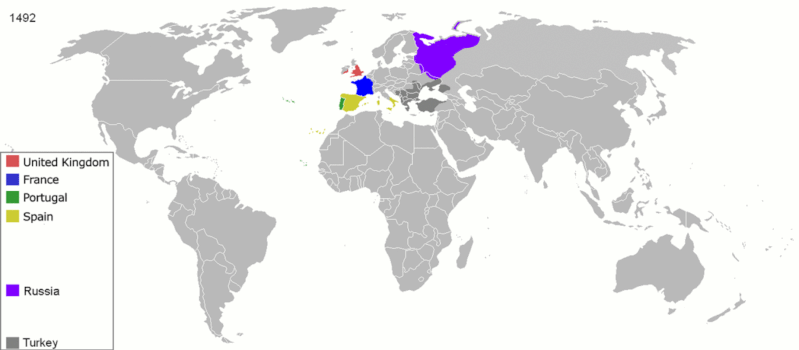
English: Map indicating the territories colonized by the European powers, United States and Japan.
Русский: Карта с указанием территорий, колонизированных Европейскими державами, Соединёнными штатами и Японией.
|
||||||||||||||||
| ວັນທີ | ໒໓ ມິຖຸນາ ໒໐໐໘ (original upload date) | ||||||||||||||||
| Source | Transferred from en.wikipedia to Commons. | ||||||||||||||||
| ຜູ້ຂຽນ | ArdadN at ອັງກິດ ວິກິພີເດຍ | ||||||||||||||||
| Other versions |
The maps can be seen separately by using this template:
Derivative works of this file: |
||||||||||||||||
.gif)
.jpg)
._LOC_2001620596.jpg)
Licensing
| I, the copyright holder of this work, release this work into the public domain. This applies worldwide. In some countries this may not be legally possible; if so: I grant anyone the right to use this work for any purpose, without any conditions, unless such conditions are required by law. |
ປະຫວັດໄຟລ໌
ຄລິກທີ່ ວັນທີ/ເວລາ ເພື່ອເບິ່ງໄຟລ໌ດັ່ງທີ່ມັນປາກົດໃນເວລານັ້ນ
| ວັນເວລາ | ຮູບຍໍ່ | ມິຕິ | ຜູ້ໃຊ້ | ຄວາມເຫັນ | |
|---|---|---|---|---|---|
| ປະຈຸບັນ | 15:40, 5 ຕຸລາ 2020 | | 1,849 × 810(2.08 MB) | Ориенталист | Colour correction |
| 14:19, 10 ພຶດສະພາ 2020 |  | 800 × 379(606 KB) | Ориенталист | Cosmetic changes | |
| 09:39, 5 ເມສາ 2020 |  | 800 × 351(561 KB) | Ориенталист | Last time i forgot 1914. Аdded it, little changes | |
| 09:49, 4 ເມສາ 2020 |  | 800 × 351(495 KB) | Ориенталист | Changed maps for 1492, 1550, 1660, 1754. Added a map for 1600. | |
| 11:29, 9 ມັງກອນ 2019 |  | 1,425 × 625(101 KB) | ArdadN | fixed Ireland 1754, Morocco 1914, Russian-German border 1885 and 1914, German-French border 1885 and 1914, German-Danish border 1885, Austria and Sudetenland 1938 | |
| 08:54, 23 ກໍລະກົດ 2018 |  | 1,425 × 625(101 KB) | SuperSucker | fix - believe in 1938 ethiopia was under european occupation as well.. italy had taken the capital Addis-Abeba in 1936 indeed | |
| 20:27, 4 ມິຖຸນາ 2012 |  | 1,425 × 625(101 KB) | Mnlk | i corrected the error that falsly depicted ethiopia as colony of fascist italy | |
| 19:49, 19 ກຸມພາ 2011 |  | 1,425 × 625(246 KB) | NordNordWest | corrected according to http://de.wikipedia.org/w/index.php?title=Benutzer_Diskussion%3ANordNordWest&action=historysubmit&diff=85468547&oldid=85447379 | |
| 19:40, 18 ກຸມພາ 2011 |  | 1,425 × 625(236 KB) | NordNordWest | corrected according to http://de.wikipedia.org/w/index.php?title=Benutzer_Diskussion%3ANordNordWest&action=historysubmit&diff=85447379&oldid=85351900 | |
| 19:42, 16 ກັນຍາ 2010 |  | 1,425 × 625(257 KB) | NordNordWest | further corrections |
ການໃຊ້ໄຟລ໌
ໜ້າຕໍ່ໄປນີ້ເຊື່ອມໂຍງຫາໄຟລ໌ນີ້:
ການໃຊ້ໄຟລ໌ທົ່ວໂລກ
ວິກິອື່ນ ໆ ຕໍ່ໄປນີ້ໃຊ້ໄຟລ໌ນີ້:
- ການໃຊ້ງານເທິງ ar.wikipedia.org
- ການໃຊ້ງານເທິງ av.wikipedia.org
- ການໃຊ້ງານເທິງ azb.wikipedia.org
- ການໃຊ້ງານເທິງ az.wikipedia.org
- ການໃຊ້ງານເທິງ ba.wikipedia.org
- ການໃຊ້ງານເທິງ be-tarask.wikipedia.org
- ການໃຊ້ງານເທິງ be.wikipedia.org
- ການໃຊ້ງານເທິງ bg.wikipedia.org
- ການໃຊ້ງານເທິງ bn.wikipedia.org
- ການໃຊ້ງານເທິງ ce.wikipedia.org
- ການໃຊ້ງານເທິງ cs.wikipedia.org
- ການໃຊ້ງານເທິງ da.wikipedia.org
- ການໃຊ້ງານເທິງ de.wikipedia.org
- ການໃຊ້ງານເທິງ diq.wikipedia.org
- ການໃຊ້ງານເທິງ en.wikipedia.org
- History of Europe
- Early modern period
- Maritime history
- Colonial empire
- History of colonialism
- User:Palaeovia
- Portal:Maps/Maps/World
- Portal:Maps/Maps/World/18
- History of globalization
- User talk:AtomAtom
- Western world
- User:Meclee/proj4-sandbox
- User:Kazkaskazkasako/Books/History
- Outline of globalization
- Decoloniality
- Wikipedia:Graphics Lab/Map workshop/Archive/Apr 2014
- User:Bongan
- User:Bongan/genetic history of the human race
- ການໃຊ້ງານເທິງ en.wikibooks.org
View more global usage of this file.