
ຮູບ:Cambodia provinces numbered.png
ບໍ່ມີຂະໜາດລະອຽດກວ່າ
Cambodia_provinces_numbered.png (400 × 323 ປິກເຊລ, ຂະໜາດໄຟລ໌: 15 KB, MIME type: image/png)

|
This locator map image could be re-created using vector graphics as an SVG file. This has several advantages; see Commons:Media for cleanup for more information. If an SVG form of this image is available, please upload it and afterwards replace this template with
{{vector version available|new image name}}.
It is recommended to name the SVG file “Cambodia provinces numbered.svg”—then the template Vector version available (or Vva) does not need the new image name parameter. |
ສະຫຼຸບ
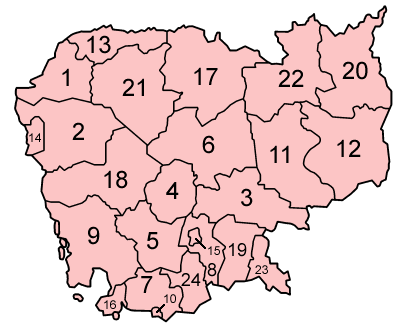
Map of the provinces of Cambodia.
Made by User:Golbez based on a map by Morwen on en.wikipedia.org.
Licensing

|
Permission is granted to copy, distribute and/or modify this document under the terms of the GNU Free Documentation License, Version 1.2 or any later version published by the Free Software Foundation; with no Invariant Sections, no Front-Cover Texts, and no Back-Cover Texts. A copy of the license is included in the section entitled GNU Free Documentation License. |
| This file is licensed under the Creative Commons Attribution-Share Alike 3.0 Unported license. | ||
| ||
| This licensing tag was added to this file as part of the GFDL licensing update. |
ປະຫວັດໄຟລ໌
ຄລິກທີ່ ວັນທີ/ເວລາ ເພື່ອເບິ່ງໄຟລ໌ດັ່ງທີ່ມັນປາກົດໃນເວລານັ້ນ
| ວັນເວລາ | ຮູບຍໍ່ | ມິຕິ | ຜູ້ໃຊ້ | ຄວາມເຫັນ | |
|---|---|---|---|---|---|
| ປະຈຸບັນ | 08:54, 20 ທັນວາ 2005 | | 400 × 323(15 KB) | Golbez | Map of the provinces of Cambodia. Made by User:Golbez based on a map by Morwen on en.wikipedia.org. Category:Maps of Cambodia |
ການໃຊ້ໄຟລ໌
ໜ້າຕໍ່ໄປນີ້ເຊື່ອມໂຍງຫາໄຟລ໌ນີ້:
ການໃຊ້ໄຟລ໌ທົ່ວໂລກ
ວິກິອື່ນ ໆ ຕໍ່ໄປນີ້ໃຊ້ໄຟລ໌ນີ້:
- ການໃຊ້ງານເທິງ ace.wikipedia.org
- ການໃຊ້ງານເທິງ ar.wikipedia.org
- ການໃຊ້ງານເທິງ ast.wikipedia.org
- ການໃຊ້ງານເທິງ be-tarask.wikipedia.org
- ການໃຊ້ງານເທິງ bg.wikipedia.org
- ການໃຊ້ງານເທິງ da.wikipedia.org
- ການໃຊ້ງານເທິງ en.wikipedia.org
- ການໃຊ້ງານເທິງ fa.wikipedia.org
- ການໃຊ້ງານເທິງ fi.wikipedia.org
- ການໃຊ້ງານເທິງ ja.wikipedia.org
- ການໃຊ້ງານເທິງ lt.wikipedia.org
- ການໃຊ້ງານເທິງ mk.wikipedia.org
- ການໃຊ້ງານເທິງ nl.wikipedia.org
- ການໃຊ້ງານເທິງ nn.wikipedia.org
- ການໃຊ້ງານເທິງ no.wikipedia.org
- ການໃຊ້ງານເທິງ pam.wikipedia.org
- ການໃຊ້ງານເທິງ su.wikipedia.org
- ການໃຊ້ງານເທິງ uk.wikipedia.org
- ການໃຊ້ງານເທິງ war.wikipedia.org
- ການໃຊ້ງານເທິງ wuu.wikipedia.org
- ການໃຊ້ງານເທິງ zh-yue.wikipedia.org
View more global usage of this file.